


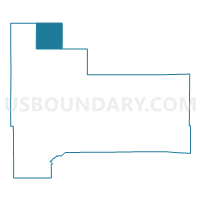
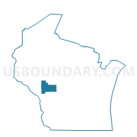
CLEVELAND - T 1 Voting District, Jackson County, Wisconsin
About
Outline

Summary
| Unique Area Identifier | 694116 |
| Name | CLEVELAND - T 1 Voting District |
| County | Jackson County |
| State | Wisconsin |
| Area (square miles) | 35.90 |
| Land Area (square miles) | 35.90 |
| Water Area (square miles) | 0.00 |
| % of Land Area | 100.00 |
| % of Water Area | 0.00 |
| Latitude of the Internal Point | 44.54930960 |
| Longtitude of the Internal Point | -90.96627010 |
Maps

Graphs
Select a template below for downloading or customizing gragh for CLEVELAND - T 1 Voting District, Jackson County, Wisconsin


Neighbors
Neighoring Voting District (by Name) Neighboring Voting District on the Map
- ALMA - T 1 Voting District, Jackson County, WI
- BRIDGE CREEK - T 1 Voting District, Eau Claire County, WI
- FAIRCHILD - T 1 Voting District, Eau Claire County, WI
- Fairchild - V 1 Voting District, Eau Claire County, WI
- FOSTER - T 1 Voting District, Clark County, WI
- GARDEN VALLEY - T 1 Voting District, Jackson County, WI
- GARFIELD - T 1 Voting District, Jackson County, WI
- MENTOR - T 1 Voting District, Clark County, WI
- NORTHFIELD - T 1 Voting District, Jackson County, WI
Top 10 Neighboring County Subdivision (by Population) Neighboring County Subdivision on the Map
- Bridge Creek town, Eau Claire County, WI (1,900)
- Alma town, Jackson County, WI (1,044)
- Northfield town, Jackson County, WI (639)
- Garfield town, Jackson County, WI (638)
- Mentor town, Clark County, WI (584)
- Fairchild village, Eau Claire County, WI (550)
- Cleveland town, Jackson County, WI (481)
- Garden Valley town, Jackson County, WI (422)
- Fairchild town, Eau Claire County, WI (343)
- Foster town, Clark County, WI (95)
Top 10 Neighboring Place (by Population) Neighboring Place on the Map
Top 10 Neighboring Unified School District (by Population) Neighboring Unified School District on the Map
- Osseo-Fairchild School District, WI (5,541)
- Augusta School District, WI (4,420)
- Alma Center School District, WI (3,066)
Top 10 Neighboring State Legislative District Lower Chamber (by Population) Neighboring State Legislative District Lower Chamber on the Map
Top 10 Neighboring State Legislative District Upper Chamber (by Population) Neighboring State Legislative District Upper Chamber on the Map
Top 10 Neighboring 111th Congressional District (by Population) Neighboring 111th Congressional District on the Map
Top 10 Neighboring Census Tract (by Population) Neighboring Census Tract on the Map
- Census Tract 1, Eau Claire County, WI (4,817)
- Census Tract 9603, Jackson County, WI (4,077)
- Census Tract 9602, Jackson County, WI (3,293)
- Census Tract 9508, Clark County, WI (3,173)